This site requires that JavaScripts be enabled in your browser. For instructions,
click here
+ Contact NASA
Directory Listing -- polarimetry
DATA FILES
‹‹‹‹ Back One
- history -
Forward One ››››
+ Return to Polarimetry Home Page
To download a file
right click
on its link and select save.
Files in this folder:
Size (bytes):
Modified:
+ frontiers-paper-ver-01.tar.gz
42648
2022-01-05 19:07pm
+ OceanLUT_Coated_0.85_30_650_123_100001_V_P11Only.mat
3491820006
2022-07-07 17:47pm
+ OceanLUT_Coated_0.85_30_650_123_100001_V_0.0000001_P11Only.mat
3491836791
2022-07-25 21:34pm
+ OceanLUT_Coated_0.85_100_650_123_100001_V_0.0000001_Imag0.3_scatnlay_P11Only.mat
4711758372
2023-06-05 01:08am
+ OceanLUT_Coated_0.85_100_650_123_100001_V_0.0000001_Imag0.3_scatnlay.md5
107
2023-06-07 17:37pm
+ OceanLUT_Coated_0.85_100_650_123_100001_V_0.0000001_Imag0.3_scatnlay.dat
16440579544
2023-02-21 16:26pm
+ OceanLUT_100_100_0.250_2000bins_750CRI.mat.md5
77
2021-05-21 17:46pm
+ OceanLUT_100_100_0.250_2000bins_750CRI.mat
3258705358
2021-11-18 19:28pm
+ OceanLUT_100_100_0.250_2000bins_750CRI.dat.md5
77
2021-05-21 17:46pm
+ OceanLUT_100_100_0.250_2000bins_750CRI.dat
2964014732
2020-10-24 12:41pm
+ CloudLUT_100_100_0.350_700bins_1400CRI_ln2rKr_Twomey.mat.md5
90
2022-08-03 18:03pm
+ CloudLUT_100_100_0.350_700bins_1400CRI_ln2rKr_Twomey.mat
3504833721
2022-08-01 20:58pm
+ CloudLUT_100_100_0.350_700bins_1400CRI_ln2rKr_Twomey.dat.md5
90
2022-08-03 17:10pm
+ CloudLUT_100_100_0.350_700bins_1400CRI_ln2rKr_Twomey.dat
3190895156
2022-07-11 17:33pm
+ CloudLUT_100_100_0.350_10000bins_100CRI.mat.md5
85
2022-01-12 14:45pm
+ CloudLUT_100_100_0.350_10000bins_100CRI.mat
3538940533
2022-01-12 14:45pm
+ CloudLUT_100_100_0.350_10000bins_100CRI.dat.md5
85
2022-01-12 14:41pm
+ CloudLUT_100_100_0.350_10000bins_100CRI.dat
3256082608
2022-01-12 14:41pm
+ BlackCarbon_195_i096_LUT_draft.tar.gz
231012
2026-06-24 11:19am
+ BlackCarbon_195_i096_LUT_draft.md5
138
2026-06-24 10:20am
+ BlackCarbon_195_i096_LUT_draft.mat
250987161
2026-06-24 10:06am
+ BlackCarbon_195_i096_LUT_draft.dat
236055196
2026-06-24 10:04am
+ AerosolLUT_1000_100_0.355_650bins_2325CRI_ln2rKr_Twomey_lidar.dat.md5
107
2021-07-07 15:35pm
+ AerosolLUT_1000_100_0.355_650bins_2325CRI_ln2rKr_Twomey_lidar.dat
18157136
2021-07-07 15:35pm
+ AerosolLUT_1000_100_0.355_650bins_2325CRI_ln2rKr_Twomey.mat.md5
101
2021-07-07 15:35pm
+ AerosolLUT_1000_100_0.355_650bins_2325CRI_ln2rKr_Twomey.mat
3286395719
2021-07-07 15:35pm
+ AerosolLUT_1000_100_0.355_650bins_2325CRI_ln2rKr_Twomey.dat.md5
101
2021-07-07 15:35pm
+ AerosolLUT_1000_100_0.355_650bins_2325CRI_ln2rKr_Twomey.dat
2986252136
2021-07-07 15:35pm
+ AerosolLUT_10000_100_0.355_150bins_2325CRI_ln2rKr_Twomey.dat.md5
102
2022-01-12 07:17am
+ AerosolLUT_10000_100_0.355_150bins_2325CRI_ln2rKr_Twomey.dat
689150136
2022-01-12 07:17am
Page Curator: Jay Madigan
NASA Official: Snorre A. Stamnes
Page Last Modified:
12/05/2017
+ NASA Communications Policy
+ Freedom of Information Act
+ Budgets, Strategic Plans and Accountability Reports
+ Inspector General Hotline
+ Equal Employment Opportunity Data Posted Pursuant to the No Fear Act
+ USA.gov
+ Open Government at NASA
+ Privacy Policy and Important Notices
+ Multimedia Browser Plug-ins
+ Comments or Questions?
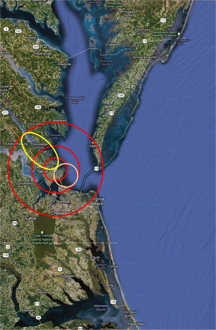
BSRN-LRC-49
Large area view.
Latitude: 37.1038
Longitude: -76.3872
Elevation: 3 m Above sea level
Scenes: urban, marsh, bay, river and farm.
Legend
The
inner red
circle is a 20km CERES foot print centered on the BSRN-LRC site.
The
pink
circle represents a possible tangential 20km foot print.
The
middle red
circle represents the area in which a 20km foot print could fall and still see the site.
Yellow
is a sample 40 deg off nadir foot print.
The
outer red
circle is the region which would be seen by a possible 40 deg off nadir foot print.
The BSRN-LRC sun tracker at the NASA Langley Research Center on a snowy day (02/20/2015)
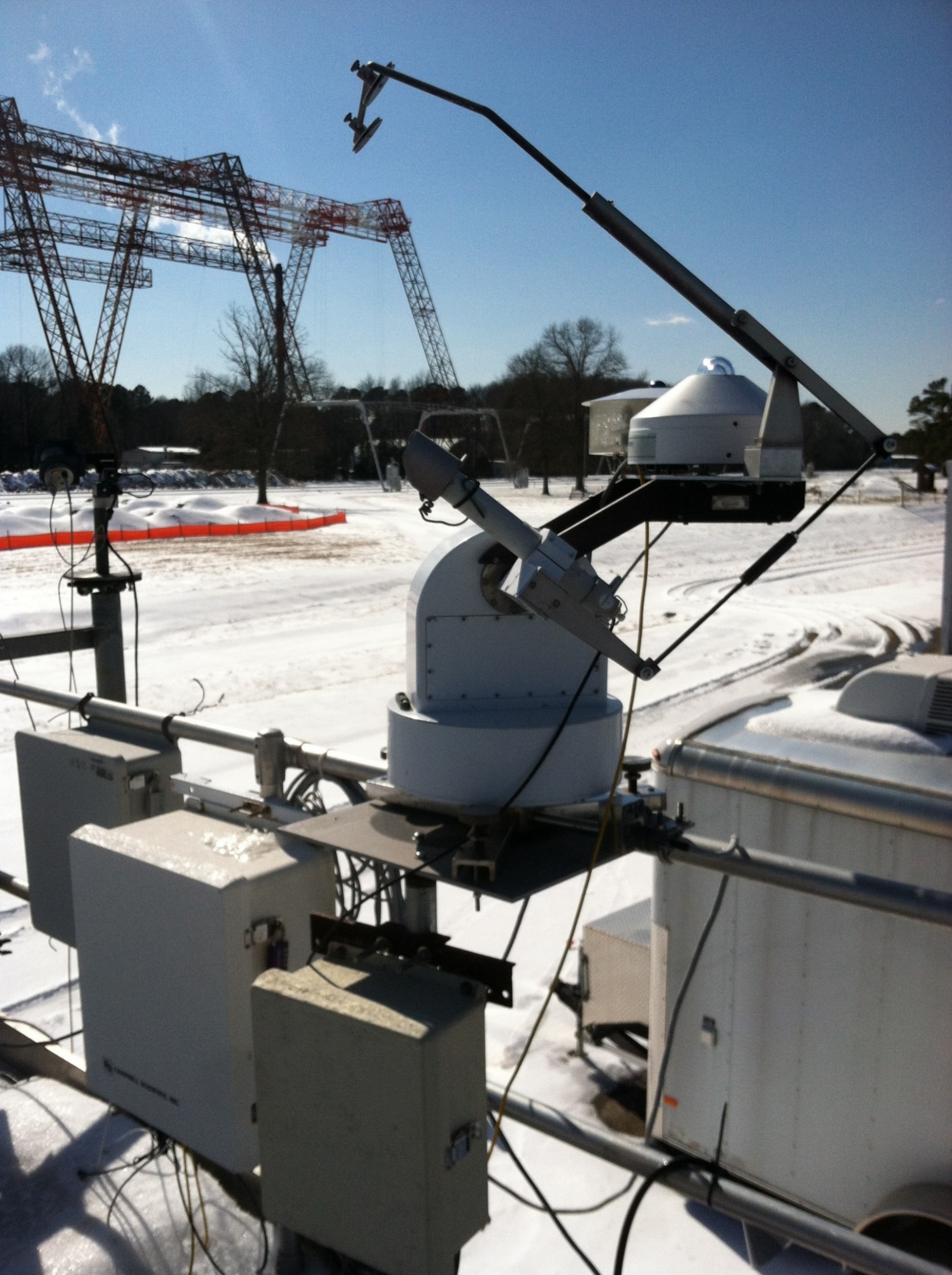 The BSRN-LRC sun tracker at the NASA Langley Research Center on a snowy day (02/20/2015)