LITE Pointing Vector
 Locating the LITE Footprint to Earth Coordinates
The as-flown LITE payload consisted of the LITE instrument attach to a Space lab 3-m pallet that was mounted in the orbiter payload bay.
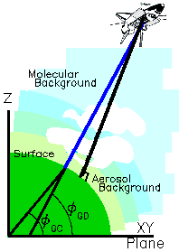
 During the operation of LITE, the orbiter was oriented with the open payload doors facing the Earth and at approximately 5 degrees off-nadir.
(Nadir is defined to be along the geodetic local vertical, which is the line perpendicular to the geoid and passing through
the orbiter center of
gravity.)
During the operation of LITE, the orbiter was oriented with the open payload doors facing the Earth and at approximately 5 degrees off-nadir.
(Nadir is defined to be along the geodetic local vertical, which is the line perpendicular to the geoid and passing through
the orbiter center of
gravity.)
At each lidar pulse, a photon stream traveled from the lidar, through the atmosphere, and to the surface of the Earth. The path along this
photon stream is referred to as the LITE pointing vector.
In the accompanying figure, the nadir line is black and the LITE pointing vector is blue.
The intersection of the LITE pointing vector with the surface of the geoid is
used to define the geodetic latitude and longitude of the LITE footprint relative to a location on the surface of the Earth.
The geodetic latitude and longitude are defined in the geodetic coordinate system.