|
LASE
 The LASE system has proven to be a reliable, accurate, and sensitive water vapor profiler
with the ability to measure water vapor mixing ratios over a large dynamic range (0.01 g/kg to 20 g/kg).
Aerosol backscatter ratios can be measured from ground to 20 km with a vertical resolution of 30 m and a
horizontal resolution of 40 m.
The LASE system has proven to be a reliable, accurate, and sensitive water vapor profiler
with the ability to measure water vapor mixing ratios over a large dynamic range (0.01 g/kg to 20 g/kg).
Aerosol backscatter ratios can be measured from ground to 20 km with a vertical resolution of 30 m and a
horizontal resolution of 40 m.
In 1997 LASE was reconfigured to fly on the NASA DC-8 and P-3 aircraft, in addition to the ER-2.
Since then LASE has participated in a number of major field programs managed by NASA's Office of
Mission to Planet Earth. Information gathered by this instrument has become an integral part
of many atmospheric studies.
As the first step towards the long range goal of developing a spaceborne LIDAR instrument,
LASE is already doing important work for atmospheric research. Vaporized water is an invisible
gas that is present everywhere in the atmosphere. The distribution of atmospheric water vapor
is of fundamental importance to weather and climate, atmospheric radiation studies,
global hydrological cycle and atmospheric chemistry. The LASE program was initiated
as an effort to produce an autonomous system for measuring water vapor levels from
airborne and spaceborne platforms using LIDAR technology.
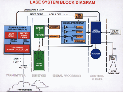
The Instrument
The LASE transmitter consists of a Ti:sapphire laser pumped by a double pulsed Nd:YAG laser.
The frequency of the Ti:sapphire laser is controlled by injection seeding using a diode laser
that is frequency locked to a water vapor line in the 815-nm region.
The "on" and "off" wavelengths are separated by less than 70 pm.
The laser pulses are sequentially transmitted with about 400 microseconds separation.
This permits the use of the same avalanche photodiodes (APD) for detecting the lidar returns.
The use of low and high light level APD's provides linear response to atmospheric and cloud/ground returns,
respectively. Lidar returns at 5 Hz are digitized and recorded, and when possible,
the data are telemetered to the LASE ground station for real-time processing and experiment control.
Operation with strong and weak absorption regions of a preselected water vapor line can be made during
the mission to optimize the measurement of water vapor in different altitude regions.
Research Objectives
The ability of a Differential Absorption Lidar (DIAL) system to measure vertical profiles
of water vapor in the lower atmosphere has been demonstrated both in ground-based and airborne experiments.
In these experiments, tunable lasers are used that require real-time experimenter control to locate and
lock onto the atmospheric water vapor absorption line for the DIAL measurements.
The Lidar Atmospheric Sensing Experiment (LASE) is the first step in a long-range effort to develop
and demonstrate autonomous DIAL systems from airborne and spaceborne platforms.
The LASE instrument was developed to measure water vapor, aerosol, and cloud profiles
from a high altitude extended range U-2 (ER-2) aircraft.
|