|
. |
LITE Overview
The LITE instrument was designed with the capability to make measurements of clouds, aerosols in the stratosphere and troposphere, the height of the planetary boundary layer (PBL), and atmospheric temperature and density in the stratosphere between 25 km and 40 km altitude. Additionally, limited measurements of the surface return strength over both land and ocean were collected to explore retrievals of surface properties. Most surface return data were collected at near-nadir angles, but several Landmark Track maneuvers were performed by Discovery to measure the angular dependence of the sea surface return. The primary geophysical parameters measured by LITE are listed below, followed by the scientific rationale behind some of the measurement objectives.
Our present understanding of the Earth's climate system and the prospects for climate change is limited in part by our knowledge of the vertical distribution of clouds. In particular, tropical cirrus is believed to significantly influence the thermal structure of the upper troposphere and thereby intensify large scale atmospheric circulations. Clouds have been extensively studied using passive satellite instruments, but current instruments are limited in their ability to sense tenuous clouds and multi-layer cloud systems. LITE can unambiguously sense even subvisible cirrus and has provided a global look at the prevalence and height of very thin clouds which are below the threshold of detection of current satellite instruments. Even deep cirrus was generally fully penetrated so that the vertical structure of the clouds could be observed and the presence of underlying cloud layers detected. By providing accurate statistics on cloud height and structure, LITE will provide guidance in the development of cloud prediction schemes for the numerical models used in climate study and weather forecasting.
The impact of tropospheric aerosols on the global radiative budget is not well understood due to our lack of knowledge on the global distribution and characteristics of natural and anthropogenic aerosols. Anthropogenic sulfate aerosols may in fact be mitigating the predicted greenhouse warming. The sources and sinks of tropospheric aerosols and the long-range transport of aerosols in the free troposphere are also poorly understood. Existing satellite instruments have limited sensitivity to aerosols, particularly over land where the major sources lie, and do not provide information on the vertical distribution. Phenomena of particular interest observed during the LITE mission are the transport of desert dust from the Sahara and the generation and transport of aerosols of anthropogenic origin, such as from biomass burning in the tropics and urban pollution from the industrialized regions of the Northern Hemisphere.
The planetary boundary layer (PBL) contains most of the aerosol and water vapor in the atmosphere and thus has a major influence on radiative fluxes. The PBL also acts as the interface where the coupling between the atmosphere and the Earth's surface occurs, and the depth of the PBL acts as a controlling factor in the transfer of moisture and momentum between them. Studies of climate sensitivity, therefore, require careful consideration of the role of the PBL. The depth of the PBL varies greatly in space and time, yet the behavior of the PBL depth is virtually unknown over most of the globe because it cannot be observed by current operational remote sensing instruments. By observing the aerosol gradient typically found at the top of the PBL, LITE provides the first global measurements of PBL height. This will aid in the validation of parameterizations of the PBL in general circulation models and improve our abilities to model the coupling between the atmosphere and the Earth's surface.
The dispersion of volcanic aerosols in the stratosphere, at altitudes from the tropopause up to 25 or 30 km, and their effects on the global radiation budget have been studied using both solar occultation and nadir-viewing satellite instruments, as well as by airborne lidars. Spaceborne lidar can provide better spatial sampling than occultation instruments, better vertical resolution and better sensitivity than a nadir-viewing instrument, and can provide global coverage which is not possible from an aircraft platform. LITE provides a more detailed look at dynamic mixing and transport processes than has been possible, and gives a better indication of the degree of spatial homogeneity of the aerosol.
Gravity waves, tides, and planetary waves play important roles in determining the large-scale circulation and structure of the stratosphere, mesosphere, and thermosphere. These phenomena are the dominant mechanisms for energy transport between the lower and upper atmosphere. Gravity waves and tides propagate upward into the stratosphere and mesosphere, where they exert a powerful drag force on the mean flow with strong secondary effects on the temperature distribution. Above the stratospheric aerosol layer, the laser backscatter becomes purely Rayleigh and can be related directly to molecular density making observation of density and temperature profiles possible.
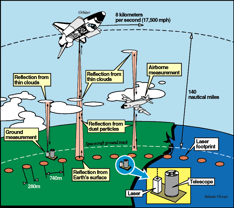
Once the lidar is calibrated, the magnitude of the surface return can be used to obtain the surface reflectance or albedo. The spectral dependence of the surface reflectance can be used to discriminate vegetation and different land surface types. Over the ocean, the spectral dependence gives a measure of the amount of dissolved and particulate matter present. Although, the primary focus of the LITE mission was on atmospheric measurements a limited set of surface data was acquired. As part of another surface study, the Shuttle was pitched 30 degrees about nadir over several ocean sites using the Shuttle Landmark Track mode. The laser footprint was maintained at a constant position during the maneuver, allowing the variation in surface backscatter with angle of incidence to be observed. This variation is highly dependent on the surface wind speed and provides a potential means of monitoring surface wind speeds over the oceans.
The transmitter of the LITE instrument is a flashlamp-pumped Nd:YAG laser which is doubled and tripled to provide simultaneous output pulses at 1064 nm, 532 nm, and 355 nm. The receiver is based on a 1-meter diameter lightweight telescope. A two-axis active-gimbaled boresight system is used to maintain alignment between the laser transmitter and the receiver. A rotatable aperture wheel is located at the focus of the telescope and acts as the field stop. One of three apertures can be selected, or a shutter can be closed to prevent light from entering the aft-optics assembly area. A portion of the received 532 nm signal is focused onto a quadrant detector which is used to derive an alignment error signal. Dichroic beamsplitters are used to separate the three-color return signals which are directed to three detectors: photomultiplier (PMT) tubes for 355 nm and 532 nm, and an avalanche photodiode (APD) for 1064 nm. The as-flown LITE payload consisted of the LITE instrument mounted on a Spacelab three-meter pallet and integrated with the pallet avionics and a pump package connected to the Shuttle Freon cooling system. The primary instrument subsystems are the Laser Transmitter Module, the Boresight Assembly, the Receiver Assembly, and the Coldplate Electronics. Part of the Coldplate Electronics is the Engineering Data System which collects environmental and status data from each of the subsystems. The LITE Camera and the OEX Autonomous Supporting Instrumentation System (OASIS) are secondary subsystems. The entire payload was mounted in, and operated from, the orbiter payload bay. The significant LITE instrument parameters are listed in the reference below.
Commanding of the LITE instrument was accomplished primarily from Mission Control in Houston. All commands go to the Instrument Controller, which parses the commands and relays them to the Aft Optics or Boresight Assembly subsystems, if required. Instrument level commands are executed by the Instrument Controller. The LITE instrument command set is very versatile, including over 200 commands to control every facet of the instrument operation. There are five predefined operating modes: Standby, Day Datatake, Night Datatake, Autonomous, and BITS. In Standby mode the high voltage to the detectors is off and the receiver aperture is closed. The instrument defaults to Standby mode at power-up and reverts to Standby when each of the other modes terminates. The BITS (Built In Test System) mode is used for instrument diagnostics. The detectors are powered on, the aperture is closed, and light emitting diodes are used to illuminate the detectors with a signal of known time dependence, simulating a backscatter signal, for the purpose of assessing the performance of the detectors and electronics. In Standby and BITS modes the laser is not fired. For Night Datatake mode the interference filters are moved out of the optical path and the aperture is moved to the 3.5 mrad position. In Day Datatake mode the interference filters are moved into the optical path and the aperture is moved to the 1.1 mrad position. In Autonomous mode the instrument automatically cycles between the Day Datatake mode and the Night Datatake mode as the orbiter crosses the terminator. The instrument monitors the background light level and decides when to change between Day and Night modes. The optical lidar return signal covers a dynamic range of 5 to 6 orders of magnitude from an altitude of 40 km to the surface return pulse. Peak signal returns from clouds vary by more than 2 orders of magnitude. The instantaneous linear dynamic range of the system is much less than this. By varying the PMT gain and by adding attenuation to the amplifier chain the system was able to cover this entire dynamic range, although not on a single profile. Observing time during the mission was split between aerosols, clouds, and the surface, which generally required separate gain and attenuation settings. The three channels can be configured independently. For example, the instrument can be set up so that surface returns are measured at 532 nm, while the 355 nm channel is used for stratospheric aerosol studies.
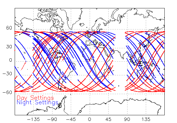
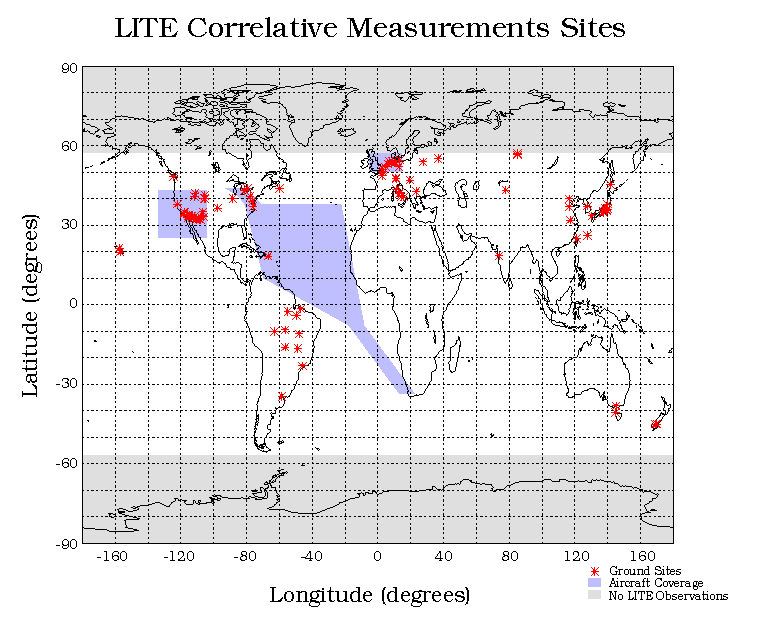
LITE was launched into a circular orbit with an initial altitude of 260 km. The altitude was decreased to 240 km for the last few days of the mission to optimize landing opportunities. A 57 degree inclination was chosen to maximize global coverage. A late afternoon launch placed the terminator crossings near the northern and southern turning points, maximizing the latitudinal coverage in darkness. The instrument was operated about 5 degrees off-nadir to avoid the possibility of occasional large return signals due to specular reflections from the surface. The orbital velocity, laser pulse rate, and beam divergence produce a series of laser footprints on the ground spaced by 740 meters, center to center. The instrument activation procedure was begun soon after the payload bay doors were opened, about 3 hours after launch, with the instrument ready to operate for the first scheduled lidar operations at 5.5 hours after launch. During the mission there were ten datatakes ranging from about 3.5 hours to 5 hours in length and 32 short snapshots of 15 minutes to 40 minutes each. When not lasing, the system was put into Standby mode. Each datatake covered roughly three orbits and was located in the time line to accommodate a mix of correlative measurement activities and studies of regional phenomena. The snapshots were focused on specific regional phenomena or correlative sites. The instrument was powered continuously for over 220 hours during the mission, with 53 hours of lasing. There were no performance anomalies which threatened mission success. However, tests conducted on the first day of the mission indicated a problem with the High Data Rate Recorder (HDRR). In spite of this, the operations team was able to downlink and archive in real time about 80% of the high rate data which was generated. Because the low-rate data stream was backed up on a different Shuttle recorder during TDRSS loss-of-signal, 100% of the instrument status data and quick-look science data were obtained. A total of 43.5 hours of high rate profiles and 53 hours of quick-look profiles were acquired. The ground tracks for the low-rate data provided good coverage between 57 N and 57 S. There was a gap in the high-rate coverage between 60 E and 85 E due to the `zone of exclusion', where neither TDRSS satellite was in view. To verify the accuracy of the measurements made by LITE, a worldwide correlative measurements program was organized by the LITE Science Steering Group. This effort employed airborne sensors and an extensive world-wide network of ground-based lidars. Over 60 ground-based lidars participated in the program, located in North and South America, Europe, Asia and Australia. Airborne instruments were particularly valuable in their ability to fly directly over the shuttle ground track and to make observations in remote regions. Aircraft were operated by NASA in the Atlantic and eastern Caribbean, extending as far south as Cape Town, South Africa. The Canadian Atmospheric Environment Services operated a Convair 580 near the coast of California and two aircraft were operated in northern Europe under the aegis of the European Space Agency. All aircraft carried at least one lidar, and several carried radiometers and in situ sensors.
Most of the above material was extracted from the paper:
| |||||||||||||||||||||||||||||||||||||||||||||||