| LITE Directory | |
| Home Page | |
| Mission Overview | |
| Data User's Guide | |
| Data FAQ's | |
| Science Steering Group | |
| Instrument | |
| Publications | |
| Images | |
| Photos | |
| Photos and Images | |
| Data Gallery | |
| Meta Data | |
| ISDB Data |
LITE Measurement Geometry
The Orbital Characteristics |
LITE, aboard the Space Shuttle Discovery, was launched into a
- near circular orbit with a 57 degree inclination to maximize global coverage,
- was at an altitude of approximately 260 km (140 n.mi.) for orbits 1 through 90, and
- was at an altitude of approximately 240 km (130 n.mi.) for orbits 90 through 150.
The Position of the Space Shuttle |
The position of the Space Shuttle is specified by the Greenwich true of date (GTOD) (geographic) coordinate system. The GTOD system is a rotating, right-handed, Cartesian system with the origin at the center of the Earth. The orientation of this system is specified with:
- The XY plane is the Earth's true of date Equator.
- The Z axis is directed along the Earth's true of date rotational axis and is positive north.
- The positive X axis is directed toward the prime meridian.
- The Y axis completes a right-handed system.
The Attitude of the Space Shuttle |
The attitude angles of the Space Shuttle are specified as a set of Euler-like rotations which define the Space Shuttle orientation as a spacecraft maneuver sequence which aligns the Space Shuttle Body Axis Coordinate System (BACS) with the GTOD axes. The rotations are defined in a yaw, pitch, roll sequence as follows:
- The spacecraft is yawed the angle alpha about the Z axis of the spacecraft. Positive rotation is X to Y.
- With the spacecraft in the position resulting from the previous rotation, the spacecraft is then pitched the angle beta about the Y axis of the spacecraft. Positive rotation is Z into X.
- With the spacecraft in the position resulting from the two previous rotations, it is then rolled the angle phi about the spacecraft X axis. Positive rotation is Y into Z.
Locating the Space Shuttle to Earth Coordinates |
The position of the Space Shuttle relative to a location on the Earth is defined in a geodetic coordinate system. This system consists of a set of parameters based on a geoid model of the Earth. The geoid model is defined by adding geoid undulations to an ellipsoid whose flattening is 1.0/298.257--- and whose equatorial radius is approximately 6378.13655 km. This geoid model serves to approximate mean sea level.
The Geodetic Coordinate System. For any selected point above the surface of a geoid, a line which is perpendicular to the geoid and passing through the selected point is formed. This line, named the geodetic local vertical, is used to define the following set of geodetic parameters:
|
geodetic altitude - the distance from the selected point to the reference geoid, measured along the geodetic local vertical,
and is positive for points outside the geoid.
geodetic latitude - measured in the plane of the local meridian from the Earth's true Equator to the geodetic local vertical, measured positive north from the Equator. longitude - measured in the plane of the Earth's true Equator from the Greenwich meridian to the local meridian, measured positive eastward. |
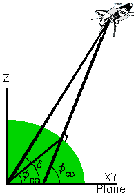 |
In the figure above, the selected point is the orbiter, and the geodetic local vertical is the line which is perpendicular to the geoid and passing through the orbiter center of gravity.
For reference information, the following parameters are also defined in the geodetic coordinate system:
- geocentric latitude - measured in the plane of the local meridian from the Earth's true Equator to the line that connects the geometric center of the coordinate system to the point where the geodetic local vertical intersects the surface of the geoid.
- declination - measured in the plane of the local meridian from the Earth's true Equator to the center of coordinate system/Space Shuttle position radius vector.
Locating the LITE Footprint to Earth Coordinates |
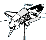
The as-flown LITE payload consisted of the LITE instrument mounted on a Space lab 3-m pallet that was mounted in the orbiter payload bay.
 |
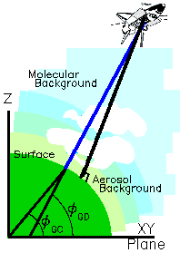
During the operation of LITE, the orbiter was oriented with the open payload doors facing the Earth and at approximately 5 degrees off-nadir. (Nadir is defined to be along the geodetic local vertical, which is the line perpendicular to the geoid and passing through the orbiter center of gravity.) |
| At each lidar pulse, a photon stream traveled from the lidar, through the atmosphere, and to the surface of the Earth. The path along this
photon stream is referred to as the LITE pointing vector.
In the figure on the right, the nadir line is black and the LITE pointing vector is blue.
The intersection of the LITE pointing vector with the surface of the geoid is used to define the geodetic latitude and longitude of the LITE footprint relative to a location on the surface of the Earth. The geodetic latitude and longitude are defined in the geodetic coordinate system. |
 |
The LITE location algorithm description explains the methods for determining:
- geodetic latitude and longitude of the LITE footprint on the surface of the Earth,
- geodetic latitude and longitude of the Space Shuttle nadir point on the surface of the Earth,
- the Space Shuttle altitude above the surface of the Earth, and
- the off-nadir angle.