| LITE Directory | |
| Home Page | |
| Mission Overview | |
| Data User's Guide | |
| Data FAQ's | |
| Science Steering Group | |
| Instrument | |
| Publications | |
| Images | |
| Photos | |
| Photos and Images | |
| Data Gallery | |
| Meta Data | |
| ISDB Data |
Observations of Saharan Dust by LITE
Because Saharan dust is typically transported in pulses lasting a few days and covering distances of several thousand kilometers, the phenomena is best monitored by orbiting instruments. During the STS-64 mission, LITE observed layers of dust over the Sahara desert and a plume of Saharan aerosol extending across the Atlantic Ocean into the Caribbean (Powell et al., 1996). Examples of these observations are shown in a series of LITE data images observed along the four Shuttle orbit transects highlighted in Figure 1. Latitude-altitude cross-sections of the lidar return signal are displayed in each image. Details on the horizontal, vertical, and pseudocolor scales are provided in the LITE data Image Description . A discussion of the LITE experiment and mission is provided by Winker et al., 1996.
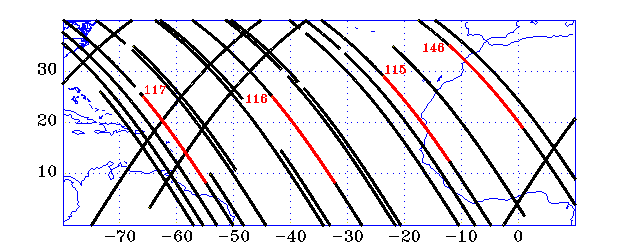
Figure 1. Orbit transects for all LITE observations from the equator to 30N and from 80W to 10E are displayed. The highlighted portions show the locations of LITE data images shown on this page for orbits 115, 116, 117, and 146.
Figure 2 displays thumbnail images showing LITE observations over the Sahara during orbit 146 at approximately 23 GMT on September 18, 1994. (Click on each panel to view an expanded and annotated version of the image. The top panel displays 5 minutes of LITE data and the bottom three panels each display 1 minute and 40 seconds of LITE data). Prominently featured at the start of this orbit transect is the Atlas Mountain range near 31N, 8W. This mountain range approximately separates a more optically thick aerosol air mass to the southeast from a relatively cleaner air mass to the northwest. Over the desert interior, the aerosol plume extends in altitude to about 5 km with complex aerosol structures embedded within the mixed layer. The SAL extends southeast until it is obscured by the optically thick clouds associated with the InterTropical Convergence Zone. Over the Atlantic Ocean, northwest of the Atlas Mountains, a considerably weaker aerosol layer is seen extending to heights of about 2 km.
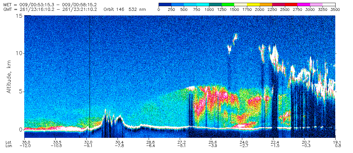

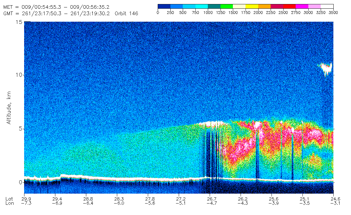
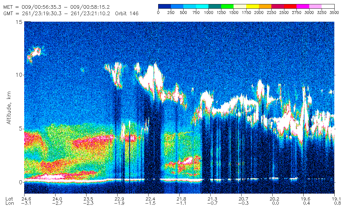
Figure 2. Orbit 146
September 18, 1994,   GMT 23:16:10  -  23:21:10
Latitude Range  35.0N - 19.1N    Longitude Range  12.0W - 0.8E
Three consecutive LITE orbits that transect the SAL are presented in Figures 3, 4, and 5 for orbits 115, 116, and 117, respectively. This set of cross-sections was observed two days prior to the set shown above for orbit 146. The ITCZ flanks the southern edge of the SAL for orbits 115 and 116. Near the African coast (north of 20N), the SAL is clearly evident, overlying the cooler marine boundary layer. Farther toward the west, aerosol loading diminishes in intensity, and the height of the mixed layer shrinks to a peak height of about 3 km. Clear separation of the SAL from the marine boundary layer becomes less obvious (fig. 5) in the western Atlantic. It is generally believed that a combination of particle sedimentation and mixing across the marine layer inversion is responsible for this change (e.g. Schutz et al., 1981; Westphal et al., 1987).


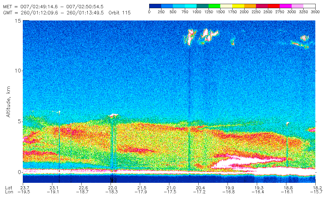

Figure 3. Orbit 115
September 17, 1994,   GMT 01:10:29 - 01:15:29
Latitude Range  29.0N - 12.6N    Longitude Range  23.6W - 12.2W

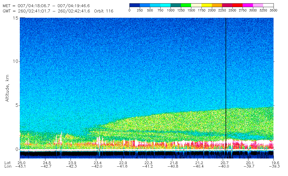
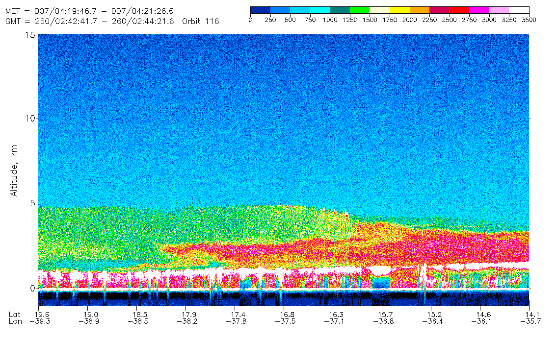
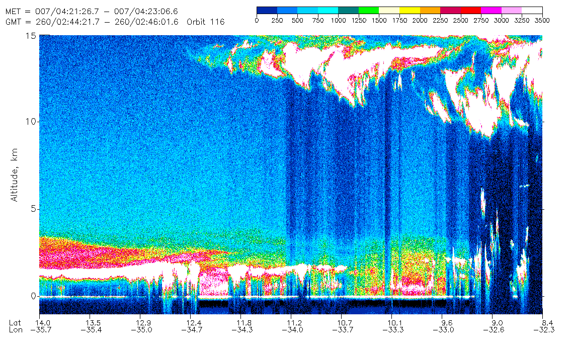
Figure 4. Orbit 116
September 17, 1994,   GMT 02:41:01 - 02:46:01
Latitude Range  25.0N - 8.4N    Longitude Range  43.1W - 32.3W
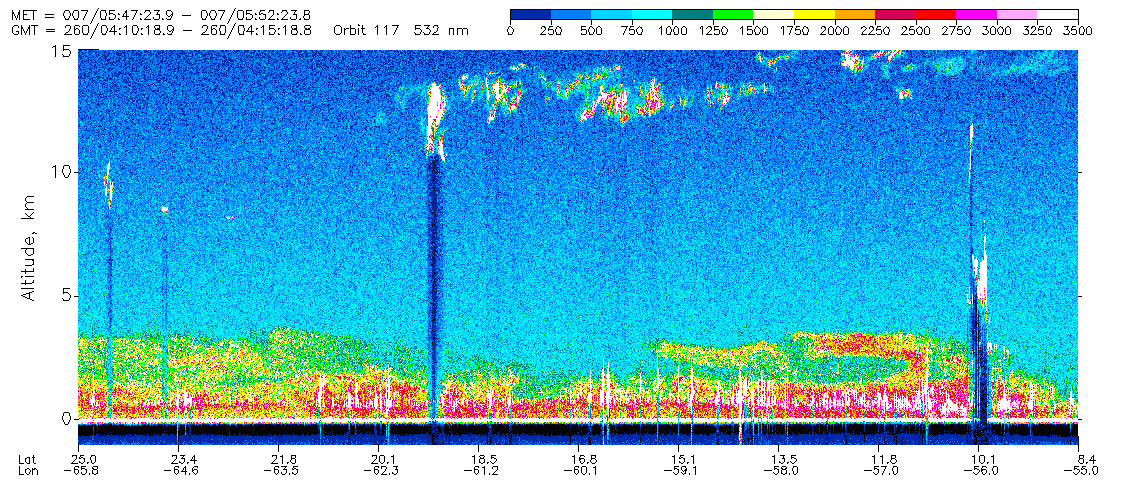
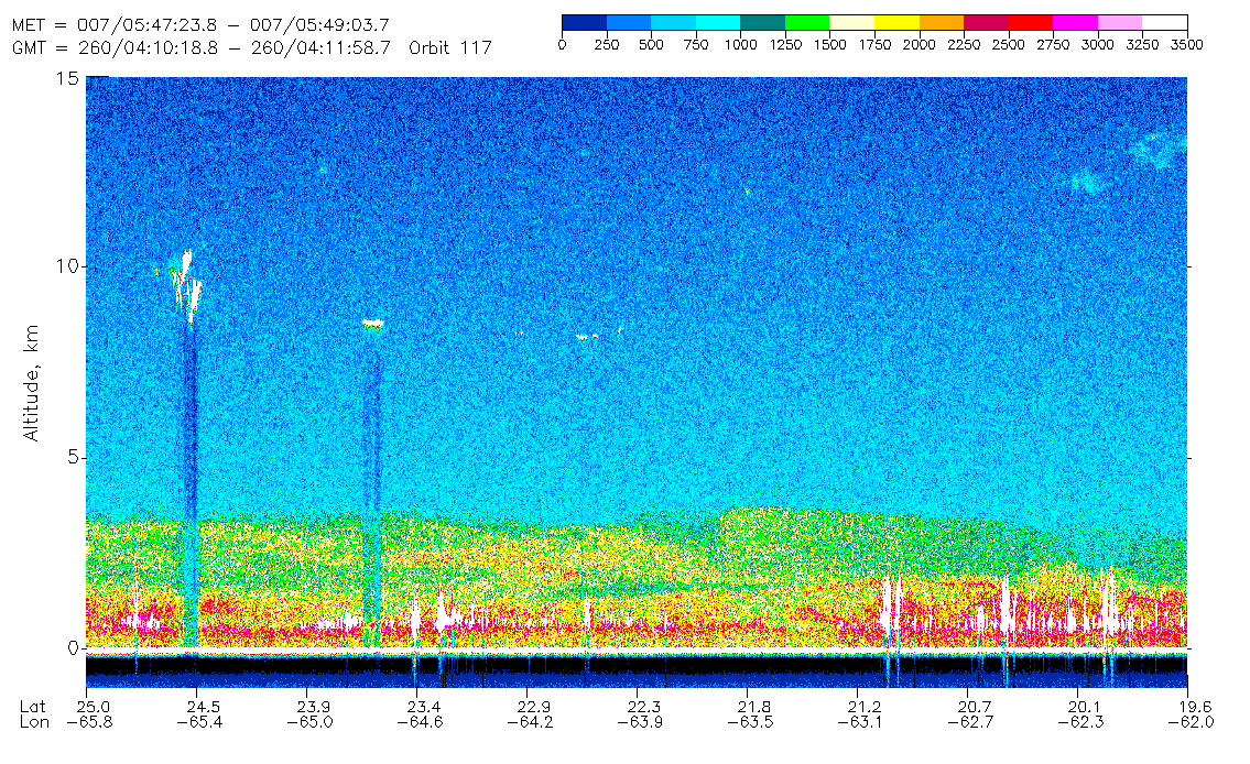

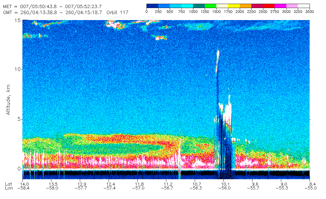
Figure 5. Orbit 117
September 17, 1994,   GMT 04:10:18 - 04:15:18
Latitude Range  25.0N - 8.4N    Longitude Range  65.8W - 55.0W
Current estimates of climate forcing from dust are uncertain due to the very poor knowledge of the distribution and optical properties of dust, and their time and space variations. Desert dust reflects solar radiation back to space, potentially resulting in a significant surface cooling, but the more significant effects may be due to the absorbing properties of dust. Unlike nonŁabsorbing aerosols, mineral particles affect infrared fluxes at the surface and at the top of the atmosphere, and also modify the vertical profile of heating within the atmosphere (Carlson and Benjamin, 1980). As illustrated by the LITE data, Saharan dust is distributed in deep layers with significant structure. Knowledge of the vertical distribution of the dust is required to calculate the infrared radiative forcing and effects on the heating profile.
References.